The chapter lead (CL) and coordinating lead author (CLA) developed a list of potential contributing authors by soliciting suggestions from the past National Climate Assessment (NCA) author team, colleagues and collaborators throughout the region, and contributors to other regional reports. Our initial list of potential authors also included CL nominees submitted to the U.S. Global Change Research Program (USGCRP). The CL and CLA discussed the Northern Great Plains, which was part of the larger Great Plains region for the Third National Climate Assessment (NCA3), with each of these nominees and, as part of that discussion, solicited suggestions for other nominees. This long list of potential contributing authors was pared down by omitting individuals who could not contribute in a timely fashion, and the list was finalized after reconciliation against key themes within the region identified by past NCA authors, the CL and CLA, and contributing author nominees. The team of contributing authors was selected to represent the region geographically and thematically, but participants from some states who had agreed to contribute were eventually unable to do so. Others were unable to contribute from the start. The author team is mostly composed of authors who did not contribute to NCA3.
The CL and CLA, in consultation with past NCA authors and contributing author nominees, identified an initial list of focal areas of regional importance. The author team then solicited input from colleagues and regional experts (identified based on their deep ties to scientific and practitioner communities across the region) on their thoughts on focal areas. This list informed the agenda of a region-wide meeting held on February 22, 2017, with core locations in Fort Collins, Colorado, and Rapid City, South Dakota. The main purpose of this meeting was to seek feedback on the proposed list of focal areas. With this feedback, the author team was able to refine our focal areas to the five themes comprising the Key Messages of the Northern Great Plains regional chapter. Of these, recreation/tourism is a focus area that is new from NCA3.
Key Message 1: Water
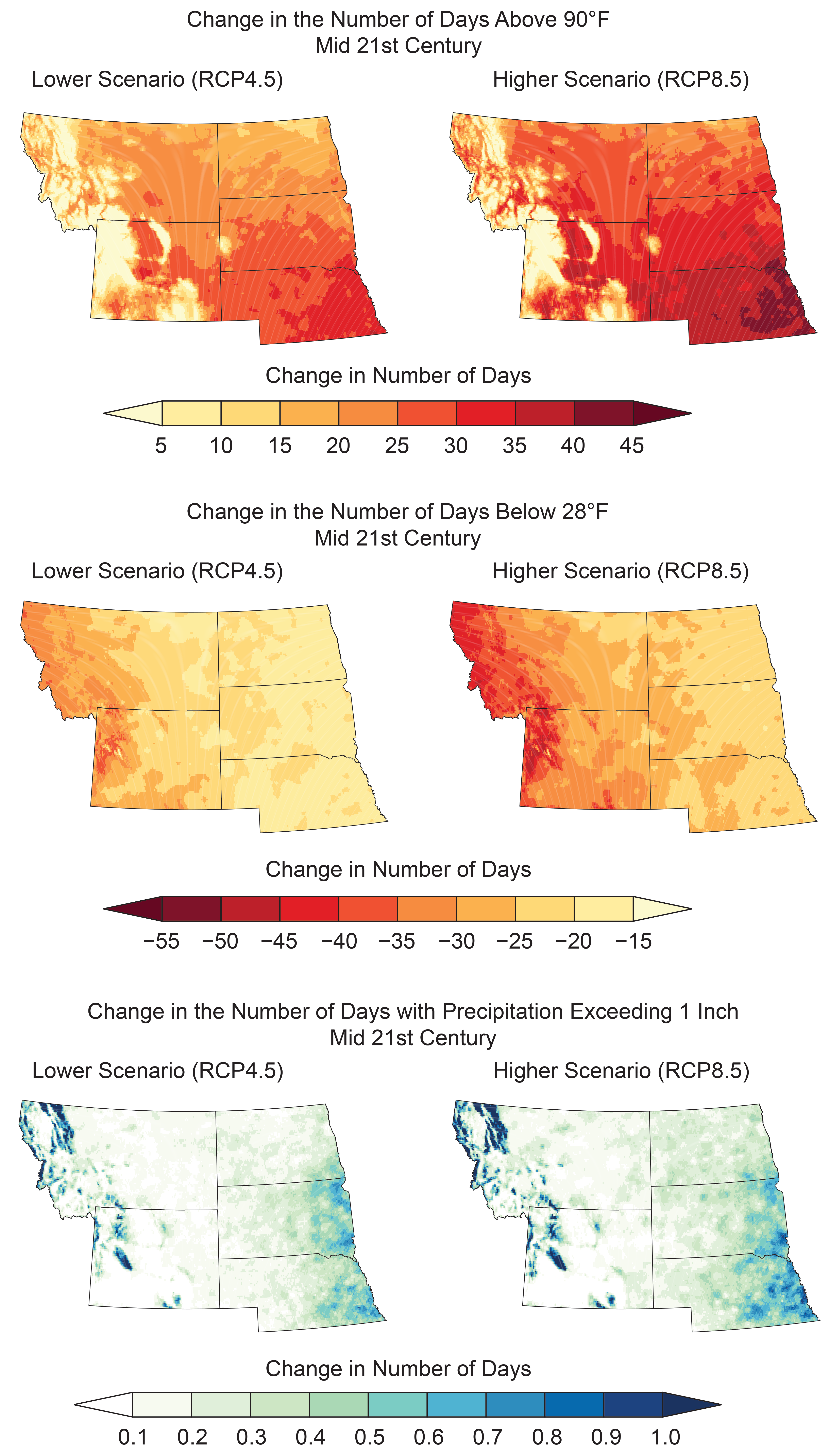
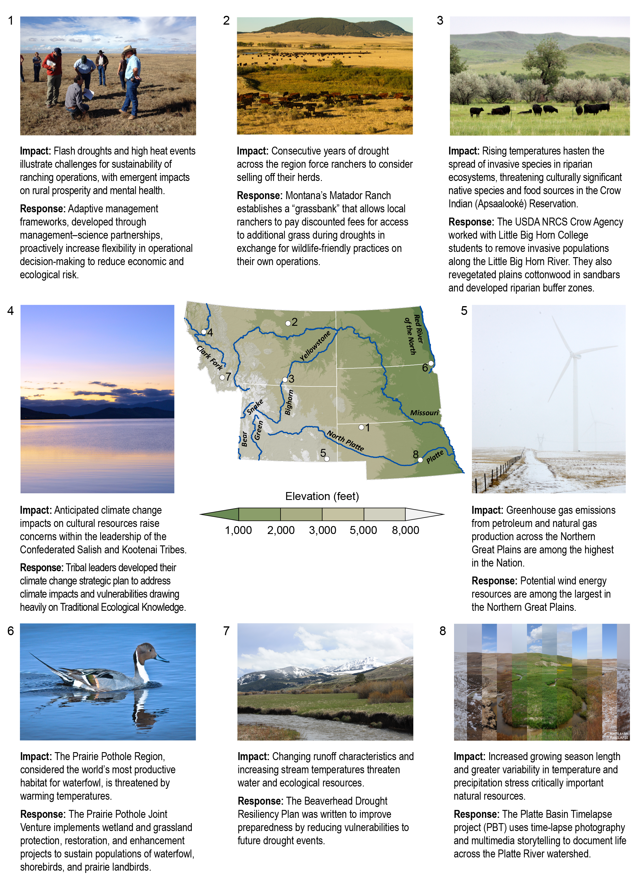
Water is the lifeblood of the Northern Great Plains, and effective water management is critical to the region’s people, crops and livestock, ecosystems, and energy industry. Even small changes in annual precipitation can have large effects downstream (very high confidence); when coupled with the variability from extreme events, these changes make managing these resources a challenge (very high confidence). Future changes in precipitation patterns, warmer temperatures, and the potential for more extreme rainfall events are very likely to exacerbate these challenges (very likely, high confidence).
Description of evidence base
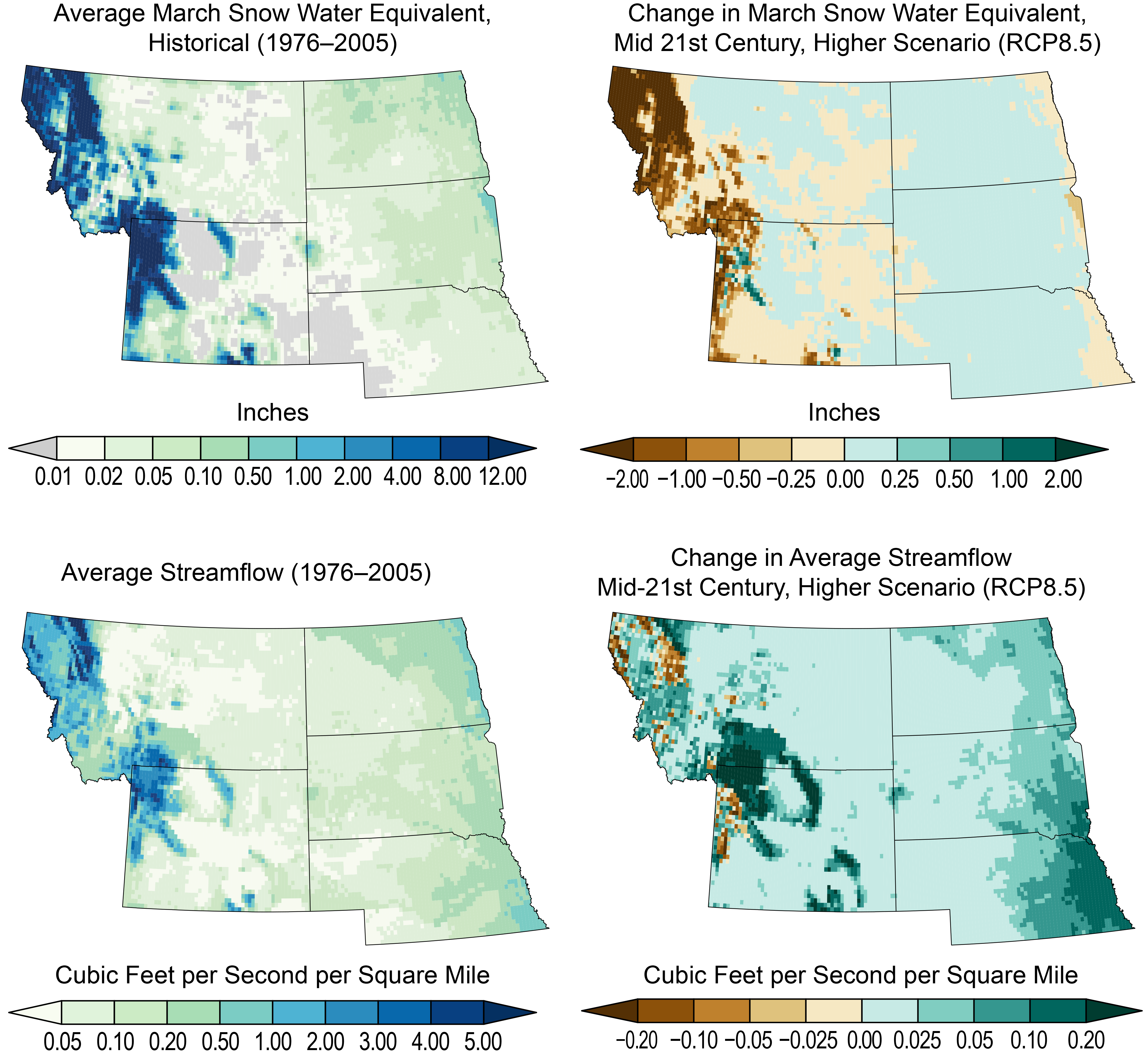
Multiple lines of research have shown that as a result of its high aridity, changes in water availability in the Northern Great Plains region are highly sensitive to small changes in climate.35,36,143,144 Despite large differences in climate from the western mountains to the eastern plains, the reliance upon reservoir storage to regulate water supplies is ubiquitous—to provide water during times of drought and to mitigate flood waters during deluges.
Natural reservoirs, groundwater, and snowpack are at risk to varying degrees. Reservoir vulnerability was recently analyzed to assess sustainable pumping rates,42 while snow and especially glaciers appear to be in steady decline in recent decades,38 attributed to global climate warming39 that is projected to continue.145
Major uncertainties
While there is high confidence in future increases in temperature, uncertainties exist as to the changes in precipitation and runoff. Perhaps most important are the uncertainties in the degree of precipitation variability from year to year and within season (based on information dating to the 1950s).35,52 These uncertainties are very likely to overwhelm the projected modest increases in precipitation.
Uncertainties exist in agricultural demands for water, reservoir operation protocols, and changes in extreme events.
Description of confidence and likelihood
There is high confidence that temperatures will rise in the region, which will likely produce less snowfall and smaller mountain snowpacks. There is very high confidence in the downstream consequences of these changes.
Key Message 2: Agriculture
Agriculture is an integral component of the economy, the history, and the culture of the Northern Great Plains. Recently, agriculture has benefited from longer growing seasons and other recent climatic changes (very high confidence). Some additional production and conservation benefits are expected in the next two to three decades as land managers employ innovative adaptation strategies (very likely, high confidence), but rising temperatures and changes in extreme weather events are very likely to have negative impacts on parts of the region (very likely, very high confidence). Adaptation to extremes and to longer-term, persistent climate changes will likely require transformative changes in agricultural management, including regional shifts of agricultural practices and enterprises (very likely, high confidence).
Description of evidence base
Several lines of research have shown that agricultural productivity is likely to increase in rangelands across the region with increasing atmospheric carbon dioxide (CO2) and warming,3,7,8 with no yield changes likely for small grain crops (for example, wheat) and yield reductions likely for row crops (for example, corn) in dryland croplands.6 The competitive ability of weeds (primarily perennial forbs such as Linaria dalmatica and annual grasses such as Bromus tectorum) is likely to increase as well, with corresponding impacts to forage production,1,2 as phenology is altered57,58 and the growing season lengthens.4,5 Forage quality is expected to decline,3,59,60 and crop yields are likely to decrease if extreme temperature events (high daytime highs or nighttime lows) occur during critical pollination and grain fill periods.9
Numerous lines of research have addressed adaptation strategies for various parts of the agricultural sector9,61,63,146,147,148
Major uncertainties
While there is high confidence in future increases in temperature, uncertainties exist as to the changes in extreme events, including the spatiotemporal aspects of high-intensity rainfall events, snowstorms, and hailstorms. Perhaps most important are the uncertainties in the degree of precipitation variability from year to year35 that influence decision-making calendars for agricultural producers.
Description of confidence and likelihood
There is very high confidence that longer growing seasons have already benefited agriculture in parts of the Northern Great Plains. There is very high confidence that increases in temperatures and atmospheric CO2 will likely increase production potential for the agricultural sector in the short term (the next 10–20 years) and that current adaptations already being implemented by a subset of producers in this region provide opportunities for assessment, further development, and adoption by the larger population of agricultural managers. There is very high confidence that rising temperatures and changes in extreme weather events are very likely to have negative impacts on parts of the region. Over the longer-term (through the end of the 21st century), predicted climate changes may require transformative changes in agricultural management, including regional shifts of agricultural practices and enterprises (very likely, high confidence).61,64
Key Message 3: Recreation and Tourism
Ecosystems across the Northern Great Plains provide recreational opportunities and other valuable goods and services that are at risk in a changing climate (very high confidence). Rising temperatures have already resulted in shorter snow seasons, lower summer streamflows, and higher stream temperatures and have negatively affected high-elevation ecosystems and riparian areas, with important consequences for local economies that depend on winter or river-based recreational activities (high confidence). Climate-induced land-use changes in agriculture can have cascading effects on closely entwined natural ecosystems, such as wetlands, and the diverse species and recreational amenities they support (very high confidence, likely). Federal, tribal, state, and private organizations are undertaking preparedness and adaptation activities, such as scenario planning, transboundary collaboration, and development of market-based tools.
Description of evidence base
State-level surveys, conducted roughly every five years, have consistently documented that the public spends millions of days each year (over $30 million in 2011) participating in nature-based recreation activities in the Northern Great Plains (e.g., U.S. Department of the Interior and U.S. Department of Commerce 2008, 2013a, 2013b, 2014a, 2014b65,66,67,68,69). The implications of climate change for outdoor recreation, and tourism more broadly, have been studied extensively around the globe (see summaries in Scott et al. 2012, Rosselló and Santana-Gallego 2014, Brice et al. 2017101,149,150). Region-specific studies are only a small subset of this large body of literature, so our understanding of potential impacts of climate change on outdoor recreation in the Northern Great Plains is sometimes inferred from other regions with similar characteristics (e.g., Hari et al. 200683). Region-inclusive studies are available (e.g., Wobus et al. 201711) for the sectors most obviously affected by climate change (such as winter recreation). Our understanding is most complete about the implications of climate change for the ecosystems upon which outdoor recreation in the Northern Great Plains depends.70 For example, the implications of climate change for wetlands and waterbirds in the Prairie Pothole Region, upon which much bird hunting and bird watching in the region depend,104,105 have been studied extensively over the past several decades (e.g., Johnson and Poiani 2016, Wright and Wimberly 201346,106). The role of agricultural land-use change (as a function of climate change as well as complex technological, policy, and market factors) in the degradation of wetland function in the region—for example through increased soil erosion and resulting wetland sedimentation or upland habitat fragmentation and resulting increases in waterfowl nest predation—has also been thoroughly assessed (e.g., Rashford et al. 2016, Sofaer et al. 201612,109).
Major uncertainties
Climate change is expected to disrupt local economies that depend on winter-based or river-based recreational activities. However, the magnitudes of these effects are uncertain. This is due largely to uncertainties about the preferences of recreationalists and the extent to which they will adapt by shifting the timing and location of their activities or by substituting towards a different set of recreational activities. For example, although climate change will make it more difficult to supply high-quality downhill skiing opportunities, this effect will be stronger in lower-elevation areas. Therefore, some skiers might adapt by simply traveling to higher-elevation downhill ski areas. Others might compensate for the shorter ski season at their favorite lower-elevation mountain by shifting some of their recreational time to an alternative outdoor activity, such as winter mountain biking. Given the potential diversity of individual preferences for adapting outdoor recreation activities to climate change, it is challenging to project with certainty the future potential impacts to recreation-dependent economies, but the impact will be larger and more immediate for some industries and companies (e.g., low-altitude ski resorts).
Another source of uncertainty is the reliance, in some cases, on scientific studies from other geographic locations to infer what the impacts of climate change might be for ecosystems, species, or recreationalists within the Northern Great Plains. For example, the effects of increased stream temperature on the susceptibility of coldwater fish species to diseases in the region are based largely on studies conducted in European coldwater fisheries.
Regarding wetlands in the Prairie Pothole Region, uncertainty about their abundance in the future arises from uncertainty about future government policies that would either exacerbate or mitigate climate-induced losses. For example, future versions of the Farm Bill may contain language that directly encourages wetland preservation (e.g., through conservation-compliance requirements) or unintentionally leads to wetland degradation (e.g., through higher subsidies for row crop insurance).
Description of confidence and likelihood
We know with very high confidence that ecosystems across the Northern Great Plains provide recreational opportunities and other valuable goods and services. We know with very high confidence that climate change is very likely affecting abiotic factors that influence these ecosystems, such as snowfall, spring snowmelt, runoff, and stream temperatures. There is high confidence that these abiotic factors are likely to affect high-elevation ecosystems and riparian areas in the Northern Great Plains. Greater confidence could be gained by conducting studies specifically within the Northern Great Plains, as opposed to drawing inferences from studies conducted in other regions of the world with similar characteristics. The consequences of ecosystem changes for local economies in the region that depend on winter-based or river-based recreational activities are currently being debated in the scientific literature, due to uncertainty about potential individual behavioral responses to changes in the recreational environment. Based on a limited number of case studies, effects of climate change on outdoor recreation-based economies are as likely as not to be negative, but this is only known with medium confidence. We know with very high confidence, however, that some natural ecosystems that local economies depend upon—in this specific case, wetlands in the Northern Great Plains—are likely to be negatively affected by climate-induced changes in agricultural land use. In turn, we know with high confidence that wetland declines will very likely harm the diverse species and recreational amenities they support. Uncertainty about future policies that could influence agricultural land-use decisions and wetland conservation outcomes precludes a higher confidence level or higher likelihood.
Key Message 4: Energy
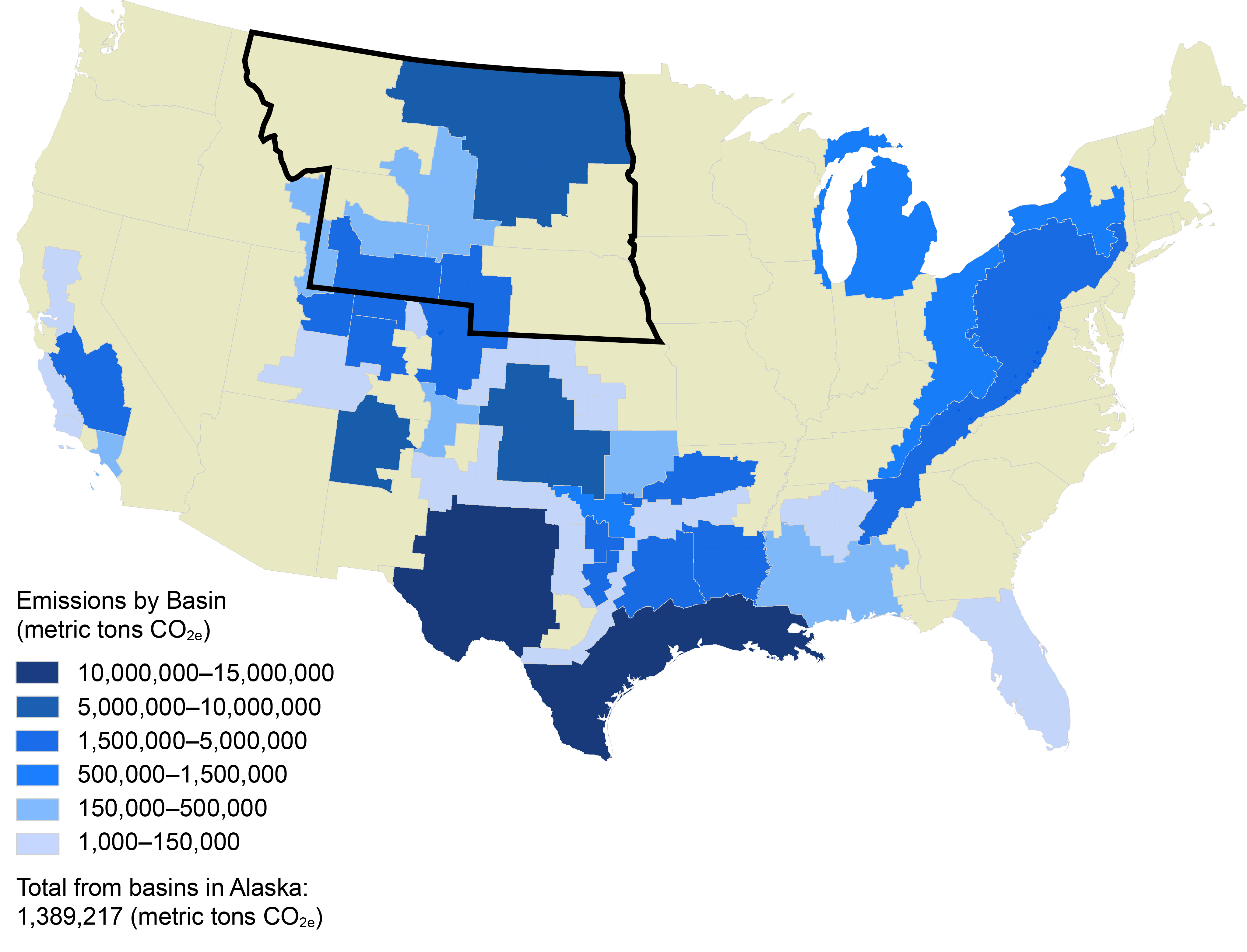
Fossil fuel and renewable energy production and distribution infrastructure is expanding within the Northern Great Plains (very high confidence). Climate change and extreme weather events put this infrastructure at risk, as well as the supply of energy it contributes to support individuals, communities, and the U.S. economy as a whole (likely, high confidence). The energy sector is also a significant source of greenhouse gases (very likely, very high confidence) and volatile organic compounds that contribute to climate change and ground-level ozone pollution (likely in some areas, very high confidence).
Description of evidence base
Fossil fuel and renewable energy production/distribution infrastructure is expanding within the Northern Great Plains, including oil and natural gas pipelines, natural gas compressor stations and storage tanks, natural gas processing plants, natural gas-fired power plants, high-voltage power lines and substations, wind farms, and even a new oil refinery and a new biorefinery in recent years (both began operations in 2015).
A number of oil and natural gas pipelines are being constructed or have been completed in recent years. In particular, the Dakota Access Pipeline began commercial service June 1, 2017, transporting crude oil from the Bakken/Three Forks production areas in North Dakota, through South Dakota and Iowa, to Pakota, Illinois. While pipelines are vulnerable to damage or disruption from heavy precipitation events and associated flooding and erosion,13 their increased use could eliminate hundreds of rail cars and trucks needed to transport crude every day. This reduces the exposure of these modes of transportation to rising temperatures, heat waves, and floods.13 Other oil and gas production and distribution infrastructure is similarly vulnerable to heavy precipitation events and flooding.
The region relies on rail lines to transport coal, and these lines are vulnerable to rising temperatures, heat waves, and floods.13 There is ample evidence of rail line vulnerability to extreme weather.151
Damage to thermoelectric power plants and electric power transmission lines from extreme weather such as heat waves and wildfires has been documented, and the risk is expected to increase.13,152
The U.S. Department of Energy (DOE) Energy Risk Profiles (1996–2014) highlight the risks to energy infrastructure in the United States from natural hazards. For example, in North Dakota, thunderstorms and lightning had the highest frequency of occurrence and property loss during this timeframe. DOE also has a series of comprehensive documents on U.S. energy sector vulnerabilities to climate change13,153 that identify important climate-related vulnerabilities for fuel transport, electricity generation, and electricity demand.
There is substantial evidence that the energy sector is a significant source of greenhouse gases that contribute to climate change, in particular from power plants, oil and gas systems, and refineries.117
Major uncertainties
Cold waves are projected to be less intense in the future, reducing the risk of disruptions from cold to energy infrastructure.13
There is not yet substantial agreement among sources as to how a changing climate will ultimately affect wind resources in the United States in general and in the Northern Great Plains in particular.153
Projected increases in precipitation in the Northern Great Plains are likely to benefit hydropower production, but this will vary by location. For example, it is known that in the Columbia River Basin, decreasing summer streamflows will reduce downstream hydropower production, and increasing winter and early spring streamflows will increase production.13 In the Missouri River Basin, projected seasonal declines in precipitation in the southern and western portion of the region are likely to reduce the water available to generate hydropower.13
Biofuel feedstocks from crops and forage grown in the Northern Great Plains are vulnerable to climate change, but the net impacts on biofuel production are uncertain.13
It is well understood that ground-level ozone (O3) is created by chemical reactions between volatile organic compounds in the presence of sunlight and would be exacerbated by climate change. What is less understood is the sensitivity of regional climate-induced O3 changes, and the science of modeling climate and atmospheric chemistry to understand future conditions.
Description of confidence and likelihood
There is high confidence that climate change and extreme weather events will likely put energy supply and infrastructure of various types at risk. There is high confidence that the energy sector is a very likely a significant source of greenhouse gases contributing to climate change. There is very high confidence that volatile organic compounds contribute to climate change and ground-level ozone pollution, and it is likely that this will worsen in the future in some areas.
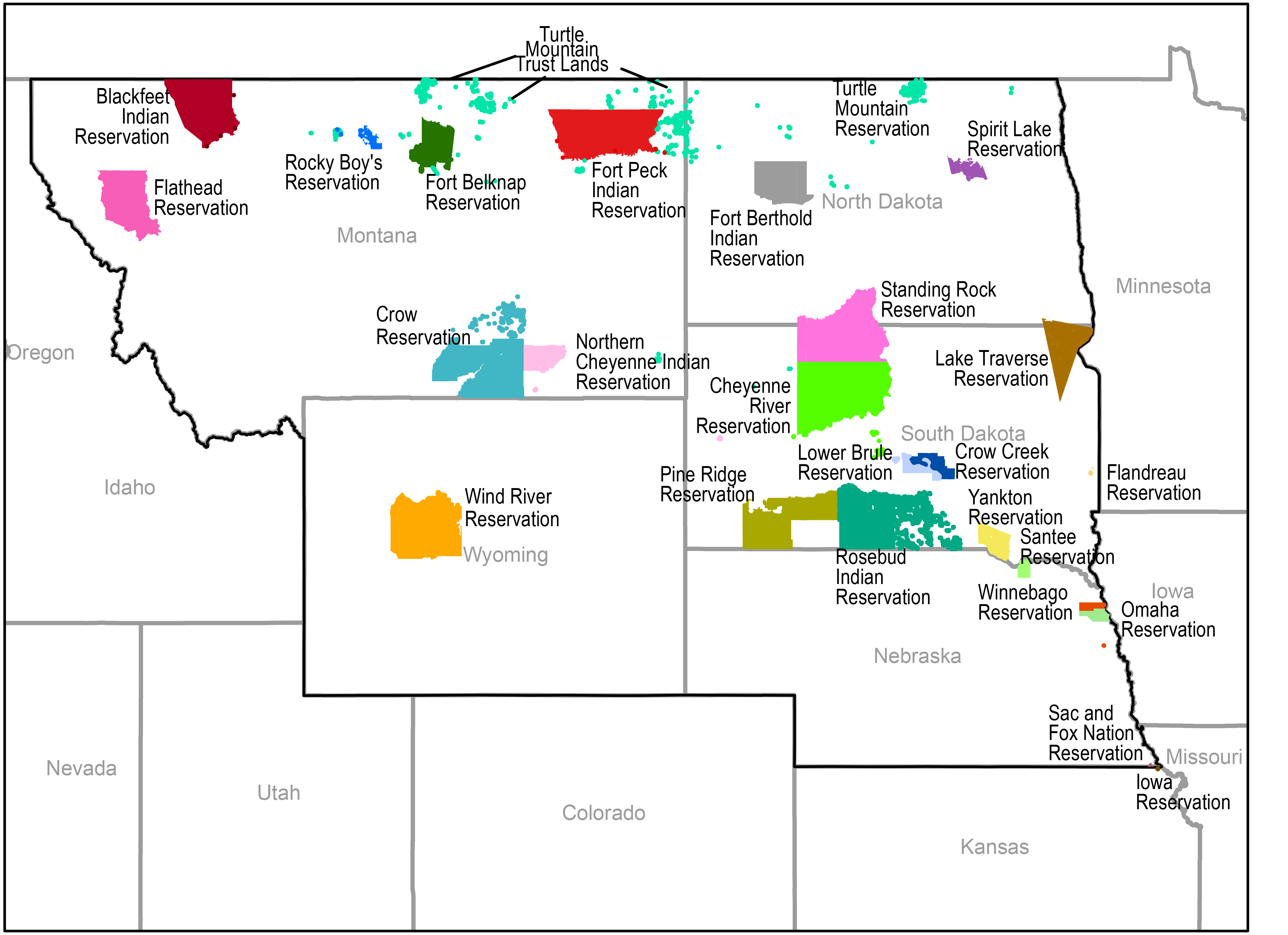
Key Message 5: Indigenous Peoples
Indigenous peoples of the Northern Great Plains are at high risk from a variety of climate change impacts, especially those resulting from hydrological changes, including changes in snowpack, seasonality and timing of precipitation events, and extreme flooding and droughts as well as melting glaciers and reduction in streamflows (likely, very high confidence). These changes are already resulting in harmful impacts to tribal economies, livelihoods, and sacred waters and plants used for ceremonies, medicine, and subsistence (very high confidence). At the same time, many tribes have been very proactive in adaptation and strategic climate change planning (very likely, very high confidence).
Description of evidence base
Multiple lines of research have shown that hydrological changes and changes in extremes have resulted in deleterious impacts to Indigenous peoples.14,18,19,20,23,24,28,121,122,123,124 During times of drought, decreased water availability negatively impacts tribal communities and livelihoods such as ranching, and already stressed water systems and infrastructure do not provide the necessary water to sustain Indigenous communities and reservations.20,28,154
Major uncertainties
The impacts of climate change in the Northern Great Plains are expected to increase risks to Indigenous reservations, communities, and livelihoods. However, there is uncertainty about how Indigenous people will be able to respond. Much of this uncertainty is due to unsettled water rights, multijurisdictional complexities, and federal funding and policies.
Description of confidence and likelihood
There is very high confidence that rising temperature and increases in flooding, runoff events, and drought are likely to lead to increases in impacts to reservations and other Indigenous communities. There is very high confidence that climate changes are already resulting in harmful impacts on tribal economies, livelihoods, and culture. However, the actual impacts and response capacities will depend on the response of regulatory systems and funding amounts.


