The majority of our Key Messages were developed over the course of two separate author meetings. The first occurred March 9–10, 2017, and the second on May 3, 2017. Both meetings were held in San Juan, Puerto Rico; however, people were also able to join remotely from Washington, DC, Raleigh, North Carolina, and the U.S. Virgin Islands (USVI). In addition, the author team held weekly conference calls and organized separate Key Message calls and meetings to review and draft information that was integral to our chapter. To develop the Key Messages, the team also deliberated with outside experts who are acknowledged as our technical contributors.
Key Message 1: Freshwater
Freshwater is critical to life throughout the Caribbean. Increasing global carbon emissions are projected to reduce average rainfall in this region by the end of the century (likely, high confidence), constraining freshwater availability, while extreme rainfall events, which can increase freshwater flooding impacts, are expected to increase in intensity (likely, medium confidence). Saltwater intrusion associated with sea level rise will reduce the quantity and quality of freshwater in coastal aquifers (very likely, high confidence). Increasing variability in rainfall events and increasing temperatures will likely alter the distribution of ecological life zones and exacerbate existing problems in water management, planning, and infrastructure capacity (likely, medium confidence).
Description of evidence base
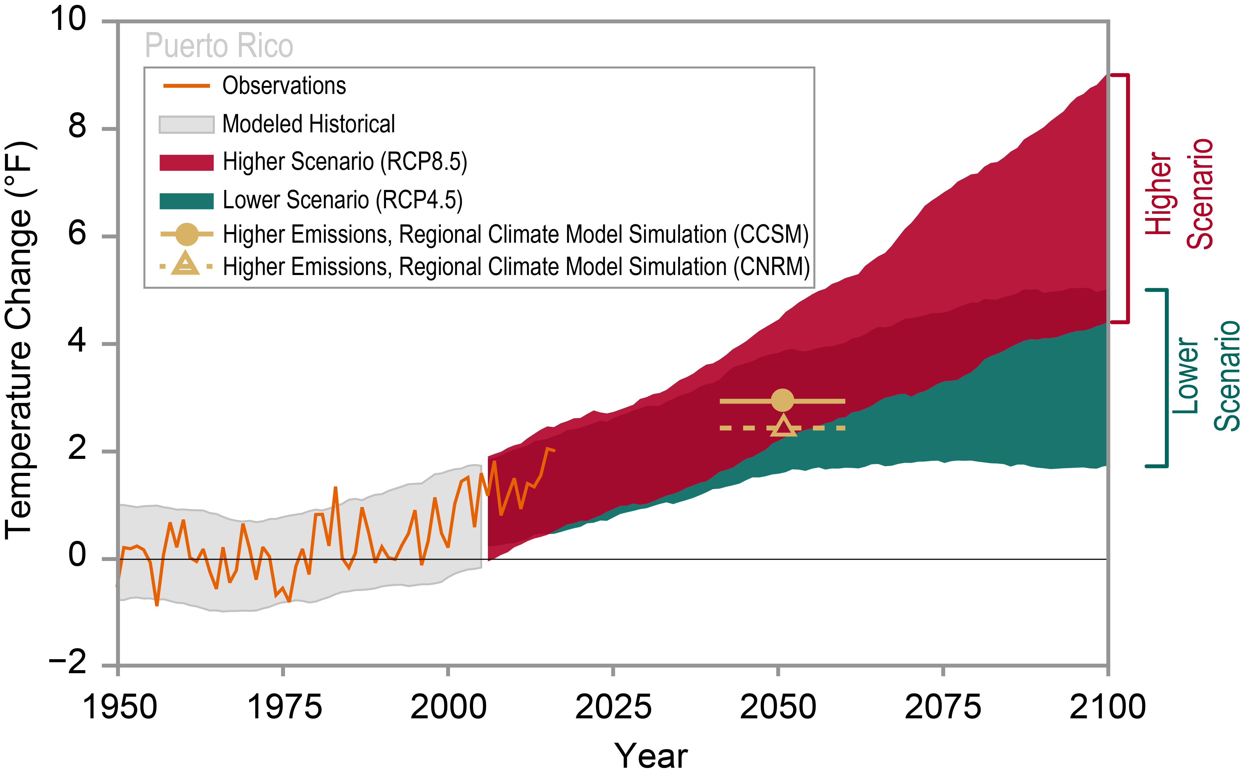
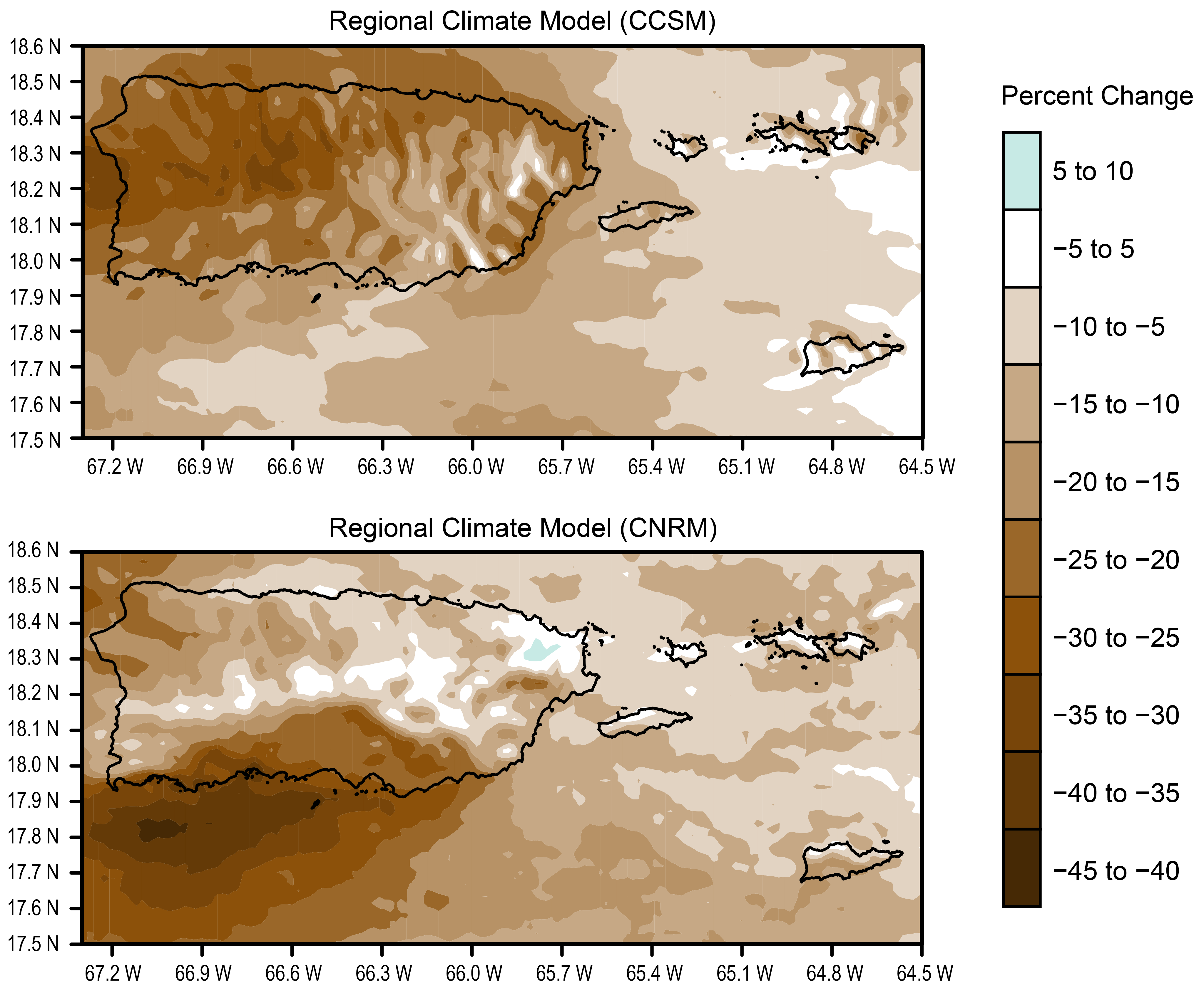
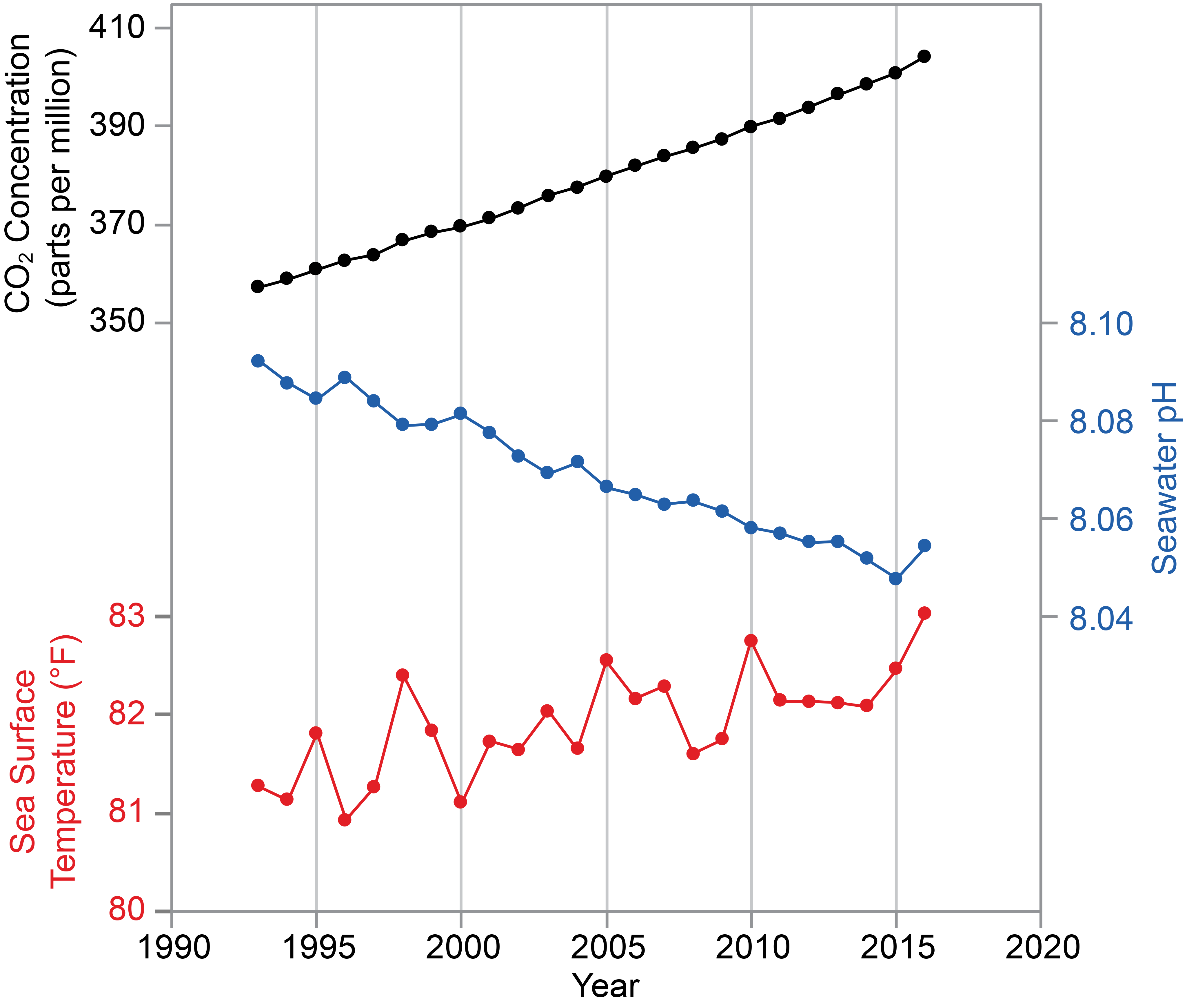
The average global atmospheric carbon dioxide (CO2) concentration has increased from 378 parts per million (ppm) in 2005 to over 406 ppm during April of 2017. The rate of increase over this period appears to be constant, and there is no indication that the rate will decrease in the future.146 Several climate change studies have concluded that owing to increased atmospheric CO2 and the consequent global climate change, rainfall will likely decrease in the region between now and the end of the century (e.g., Meehl et al. 2007, Biasutti et al. 2012, Campbell et al. 2011, Cashman et al. 20102,3,4,5). Neelin et al. (2006)147 and Scatena (1998)148 have predicted increasingly severe droughts in the region in the future. Several downscaling studies, which specifically considered Puerto Rico, predict a reduction in rainfall by the end of the century6,7,34 and constraints on freshwater availability. Furthermore, Taylor et al. (2018)149 used the most recent generation of global climate models and demonstrated that when global warming increases from 1.5°C to 2°C above the preindustrial values (1861–1900), the Caribbean experiences a shift to predominantly drier conditions. Small watersheds that feed reservoirs are typical of the Caribbean region, and they are less able to serve as a buffer for rainfall variability. Small watersheds exhibit variable drainage patterns, which in turn affect evapotranspiration, groundwater infiltration, and surface water runoff. Drainage patterns in watersheds are also affected by the specific geometry, configuration, and orientation in relation to the average direction of wind over the region, as well as the morphology of rivers. With a projected reduction in rainfall up to 30% on average for the island by the end of the century,7 certain watersheds will likely be less able to buffer rainfall variability and will likely see water deficits in the near future. Increasing variability in rainfall events and increasing temperatures will likely exacerbate existing problems in water management, planning, and infrastructure capacity.
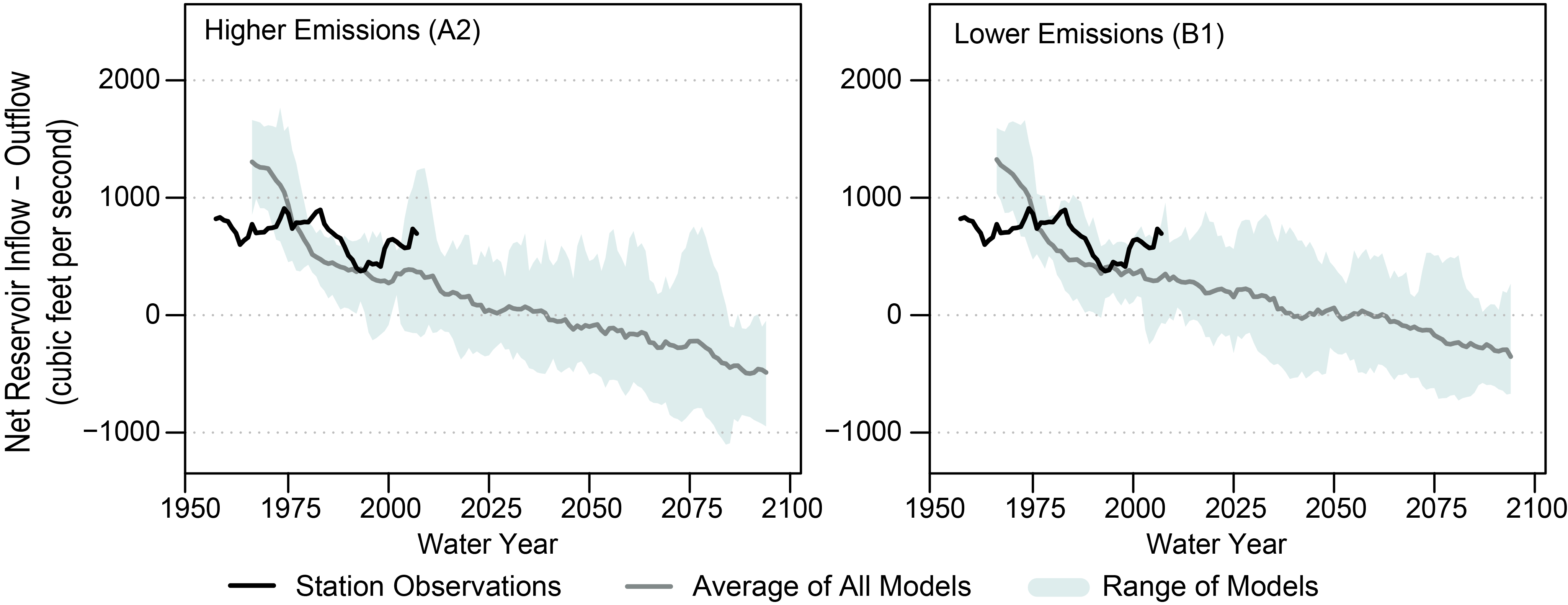
Streamflow is estimated using hydrologic models that are calibrated to networks of stream gauges and precipitation measurements. Reservoirs are considered in a permanent supply deficit if the annual streamflow leaving these reservoirs falls below zero after estimating withdrawals for human consumption, evapotranspiration, and rainfall. Projections of when deficit conditions could occur (circa 2025) are estimated using climate models.46
Saltwater intrusion associated with sea level rise will reduce the quantity and quality of freshwater in coastal aquifers. In Puerto Rico, groundwater quality can change when the water table is below sea level in coastal areas or when the intensity of pumping induces local upconing of deeper, poor-quality water.43 Upconing is the process by which saline water underlying freshwater in an aquifer rises upward into the freshwater zone due to pumping.150 When the water table is below sea level, the natural discharge of groundwater along the coast is reversed and can result in the inland movement of seawater or the upconing of low-quality water.151,152 Diminished aquifer recharge and, to a lesser extent, increased groundwater withdrawals during 2012–2015 resulted in a reduction in the freshwater saturated thickness of the South Coast Aquifer. With sea level rise, groundwater quality will likely deteriorate even further in coastal aquifers in Puerto Rico.
Major uncertainties
As global changes continue to alter the hydrological cycle across the region, water resources are expected to be affected in both quantity and quality. There is still uncertainty as to the extent and severity of these global changes on small island nations such as Puerto Rico and the USVI, despite notable advancements in downscaled modeling exercises. Current climatological observations have presented an overall increase in mean annual precipitation across Puerto Rico.153 However, climate model projections point toward an overall decrease in annual mean precipitation toward 2050 and an increase in rainfall intensity for extreme rainfall,6,7,28,30,34,154 including rainfall associated with hurricanes. There is more uncertainty regarding the frequency and duration to changes in extreme rainfall within the region.7,28,34
Selected CMIP3 (Coupled Model Intercomparison Project, phase 3) and CMIP5 global climate models (GCMs) capture the general large-scale atmospheric circulation that controls seasonal rainfall patterns within the Caribbean155 and provide justification that these GCM projections can be further downscaled to capture important rainfall characteristics associated with the islands.156 Systemic dry biases exist, however, in the GCMs.155 And many GCMs fail to capture the bimodal precipitation pattern in the region.28 The CMIP3 generation of GCMs that do capture the bimodal rainfall pattern predict extreme drying at the middle and end of this century.7,28 The CMIP5 generation of GCMs also projects drying by the middle and end of the century, but the magnitude of drying is not as large. Local and island-scale processes could affect these projected changes, since the land surface interacts with and affects both precipitation and evaporation rates.157
Description of confidence and likelihood
There is high confidence that freshwater availability will likely be constrained by the end of the century and medium confidence that extreme rainfall events will likely increase in intensity. There is high confidence that sea level rise will very likely cause saltwater intrusion impacts on coastal freshwater aquifers. There is medium confidence about likely changes to ecological life zones but low confidence about the distributional effects on the existing terrestrial ecosystems in the region.
Key Message 2: Marine Resources
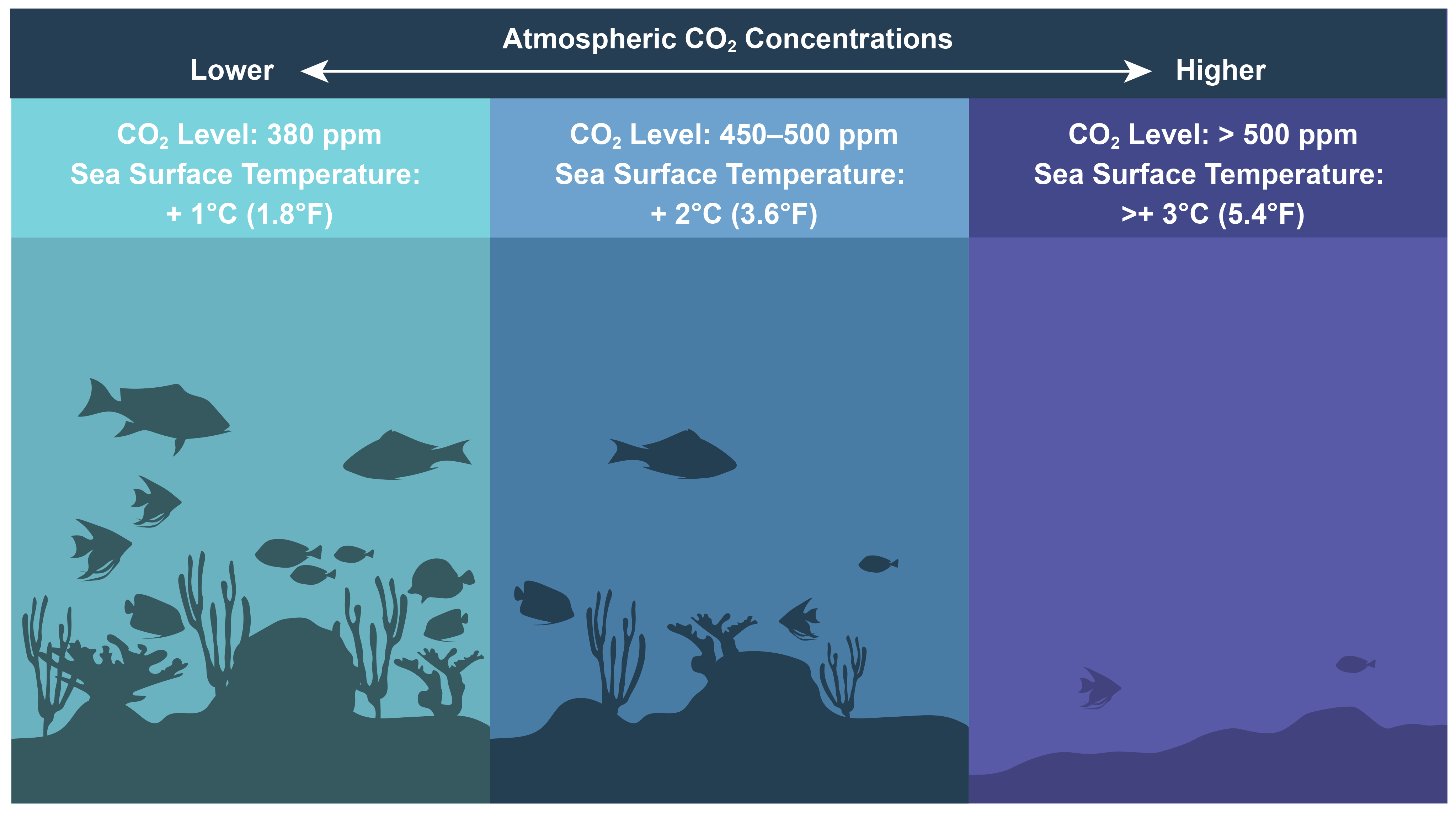
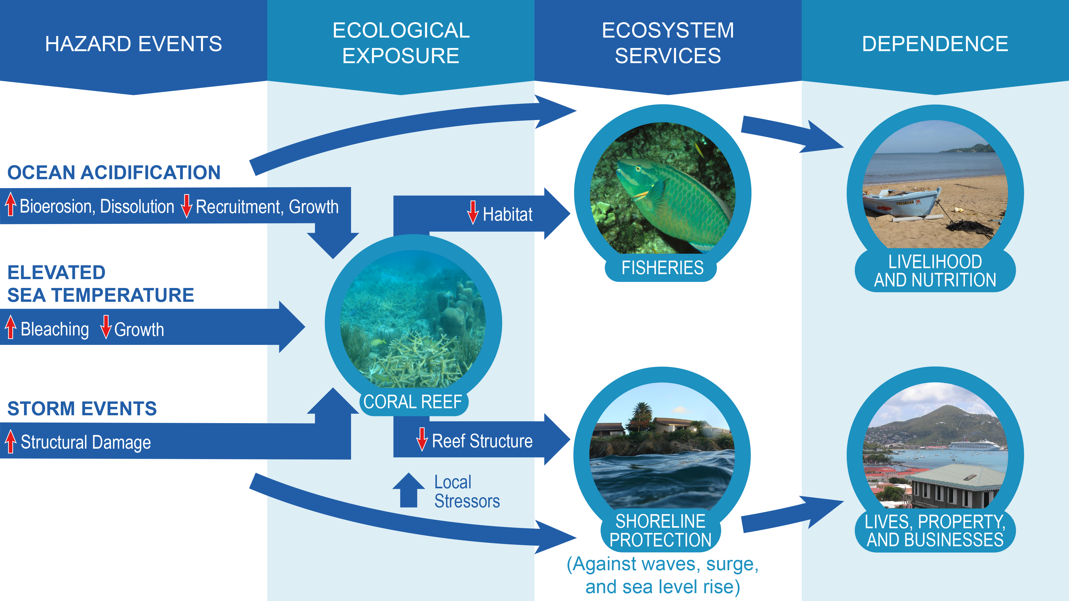
Marine ecological systems provide key ecosystem services such as commercial and recreational fisheries and coastal protection. These systems are threatened by changes in ocean surface temperature, ocean acidification, sea level rise, and changes in the frequency and intensity of storm events. Degradation of coral and other marine habitats can result in changes in the distribution of species that use these habitats and the loss of live coral cover, sponges, and other key species (very likely, high confidence). These changes will likely disrupt valuable ecosystem services, producing subsequent effects on Caribbean island economies (likely, medium confidence).
Description of evidence base
In 2006, the National Marine Fisheries Service (NMFS) listed elkhorn and staghorn corals as threatened species under the Endangered Species Act, with persistent elevated sea surface temperatures and sea level rise being two of the key factors influencing the listing decision.158 The Acropora Biological Review Team (2005) found that the number of hurricanes affecting reef ecosystems in the Caribbean has increased over the past two decades (2 hurricanes in the 1970s, 6 in the 1980s, and 12 in the 1990s). Sea surface temperature is expected to continue rising, and this implies an increasing threat to elkhorn and staghorn corals from bleaching-induced mortality and possibly an exacerbation of disease effects. In 2014, NMFS listed an additional 5 species of Atlantic/Caribbean corals (lobed, mountainous star, boulder star, pillar, and rough cactus) as threatened and reevaluated the listing of elkhorn and staghorn corals, confirming them as threatened species; it also listed 15 Indo-Pacific coral species as threatened,159 with two of the key factors being ocean warming and ocean acidification. Brainard et al.159 found that ocean warming and related effects of climate change have already created a clear and present threat to many corals that will likely continue into the future and can be assessed with certainty out to 2100. Increases in human population densities and activity levels in the coastal zone are expected to continue, meaning the vulnerability of these populations and infrastructure will likely continue increasing with climate change.160 Direct measurements at the Bermuda Atlantic Time-series Study station shows that surface ocean acidity has increased by about 12% and aragonite saturation (Ωarg) has decreased by about 8% over the past three decades.161 These values agreed with those reported across the Caribbean162 and Atlantic regions18,161 using regional and global numerical marine carbonate system models.
Many coastal regions already experience low surface seawater pH and Ωarg conditions (localized or coastal ocean acidification) due to processes other than CO2 uptake. As a result, the effect of ocean acidification on coastal zones can be several times higher and faster than typically expected for oceanic waters.163
Caribbean coral reefs in the Bahamas, Belize, Bonaire, and Grand Cayman are already experiencing significant reductions in carbonate production rates, with 37% of surveyed sites showing net erosion.164 Friedrich et al. (2012).66 concluded that calcification rates may have already dropped by about 15% within the Caribbean with respect to their preindustrial values.
Major uncertainties
The link between climate stressors such as increasing sea surface temperatures and bleaching response and increasing prevalence of disease in corals is postulated. There is some scientific evidence indicating a link, but it is hard to make definitive conclusions. Effects of climate change on fisheries in the Caribbean have not been as well studied as the effects on marine habitats, particularly coral reefs.74,165 Similarly, the social consequences of climate change and associated declines in marine fisheries and the effects on coastal communities reliant on coral reef fishery species have not been as well studied.166
Uncertainty with respect to ocean acidification is dominated by uncertainty about how ecosystems and organisms will respond, particularly due to multiple interactions with other stressors.
The value of the loss of ecosystem services to ocean acidification is unknown. Such losses are attributable to the degradation of ecosystems that support important economic marine species such as coral, conch, oysters, fish larvae, urchins, and pelagic fish in the Caribbean. There is strong evidence for decreasing carbonate production, calcification rates, coral cover, and biomass of major reef-building species throughout the Caribbean region. However, there is still not enough evidence to conclude that all these decreased ecosystem processes are due to ocean acidification.
There are only a few studies on ecosystem and organism responses to climate stressors (such as ocean warming) that consider ocean acidification in the Caribbean. For instance, low pH values could affect nursery areas of commercially important species such as tuna, presenting a source of vulnerability for the economy, but studies are scarce. Ocean acidification could also affect the food web dynamics at lower trophic levels and have physiological effects at larval stages that would likely cascade upward, affecting coral and fish recruitment.
The effects of ocean acidification on coral reefs, shellfish, fish, and marine mammals will likely cause an economic effect on fisheries, coastal protection, and tourism in the Caribbean. Ocean acidification can exacerbate the current global warming effects on coral reefs, and it will likely continue deteriorating reef conditions and cause ecological regime shifts from coral to algal reefs.77,167 The primary effect on reef communities will probably be a reduction in their capacity to recover from acute events such as thermal bleaching.
Sea level rise is currently the most immediate and well-understood climate-related threat to mangroves.70 It is not clear how mangroves will respond to elevated CO2, and some studies suggest increases may actually be beneficial to mangroves.70 Similarly, in the Caribbean where temperatures are already high, increasing temperatures, as well as declines in rainfall and corresponding increases in soil salinity during periods of drought, will likely increase plant water stress and reduce productivity. There have been limited studies on the effects of climate change on seagrass beds; therefore, these effects remain uncertain.69 Sea level rise that results in reduced sunlight due to increased water depths can lead to the loss of seagrass beds from deeper waters. As discussed previously, the loss or degradation of these habitats, which are part of the coral reef ecosystem and serve as nursery habitat for important nursery species, will likely contribute to declines in fishery productivity due to climate change.
Description of confidence and likelihood
There is high confidence that increasing ocean temperatures, changes in ocean acidity, and changes in the frequency and intensity of storms are extremely likely to affect coastal and marine resources. Large storm events within the past decade have resulted in significant effects on marine resources, particularly coral habitats and organisms that rely on them. There is medium confidence in predictions that coral habitats will likely continue to decline throughout the Caribbean, with associated effects on resources dependent on these habitats; although, scientific studies are still needed in terms of climate change effects on fisheries resources, particularly for species that are found in offshore waters or are pelagic. Changes in coral habitats are already occurring as evidenced by massive coral bleaching events (including a three-year global-level bleaching event from 2015–2017) and the increase in these events. Such changes in bleaching events are due to rising sea surface temperatures. There is high confidence that there have been changes in ocean pH and medium confidence on the ecological effects. Due to the lack of studies on the social consequences of climate change and associated losses of resources such as fisheries, there is medium confidence that effects on coastal and marine resources resulting from climate change will affect island economies. These effects can be a result of changes in availability and condition of fishery resources, loss of reefs and other coral communities that serve as coastal barriers, and effects on tourism due to loss of the resources that are primary attractions for visitors.
There is medium confidence in the ecological effects that will result due to changes in ocean pH. The CO2 system of seawater is well understood and established. As such, the understanding of the basic equilibria governing the process of ocean acidification dates back to at least 1960168 and represents a foundational understanding of modern chemical oceanography. The ecological consequences of human-induced changes to the system (that is, ocean acidification) is, however, a considerably new field. Both themes were assessed considering recent findings and based on adequate observed local data (for example, atmospheric pCO2 [carbon dioxide partial pressure] values are based on measurements of weekly air samples from St. Croix, the USVI, the United States, and Ragged Point, Barbados), complemented with empirical models. Projected changes in climate for the Caribbean islands were based on the future projections of fossil fuel emissions driven by reasonable models from the Intergovernmental Panel on Climate Change (IPCC).169 Additional empirical species response data would be useful for increasing the understanding of expected effects of ocean acidification on species and habitats in the Caribbean.
Key Message 3: Coastal Systems
Coasts are a central feature of Caribbean island communities. Coastal zones dominate island economies and are home to critical infrastructure, public and private property, cultural heritage, and natural ecological systems. Sea level rise, combined with stronger wave action and higher storm surges, will worsen coastal flooding and increase coastal erosion (very likely, very high confidence), likely leading to diminished beach area (likely, high confidence), loss of storm surge barriers (likely, high confidence), decreased tourism (likely, medium confidence), and negative effects on livelihoods and well-being (likely, medium confidence). Adaptive planning and nature-based strategies, combined with active community participation and traditional knowledge, are beginning to be deployed to reduce the risks of a changing climate.
Description of evidence base
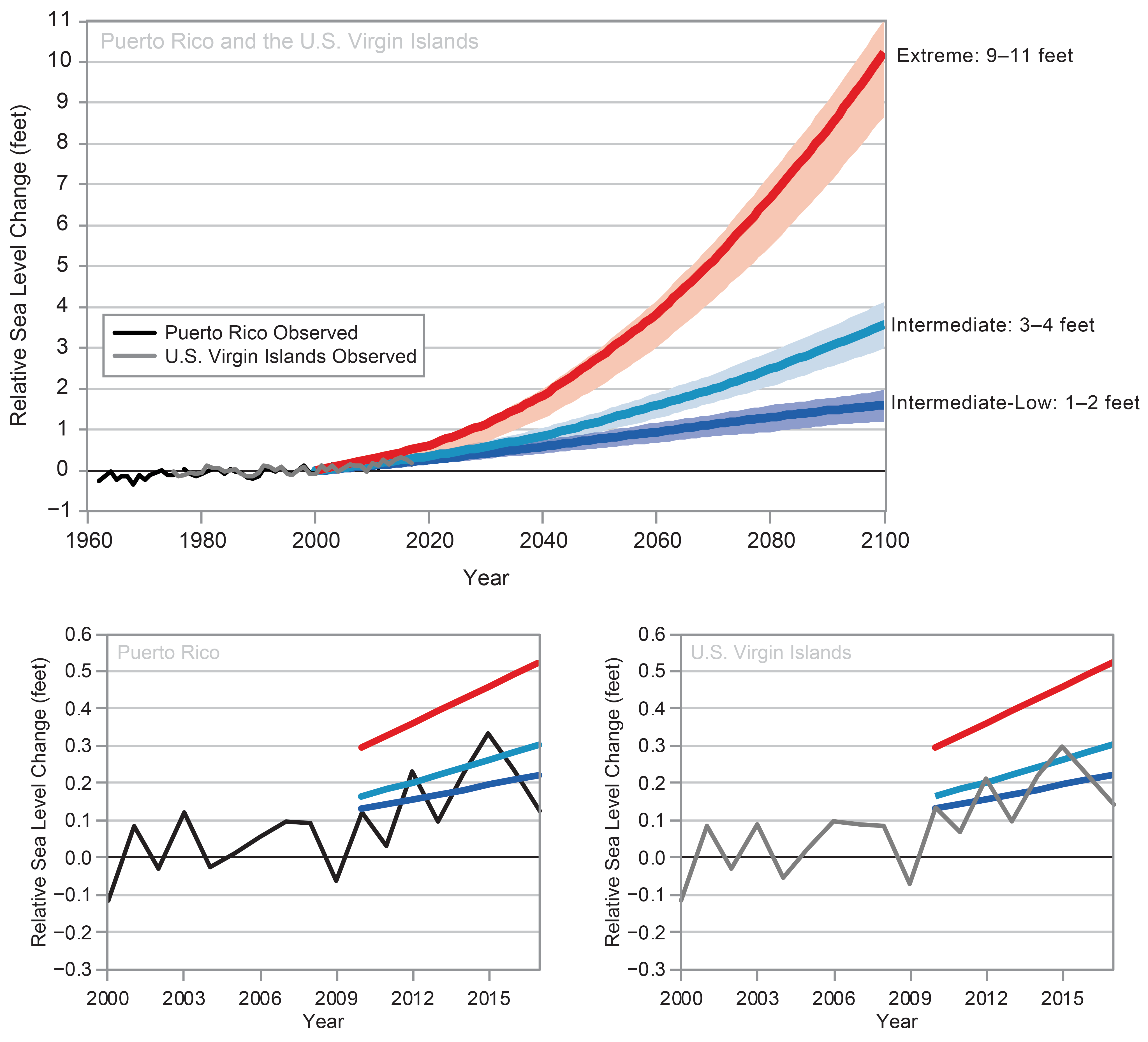
The Key Message and subsequent narrative text are based on the best available information for the U.S. Caribbean. There are not many studies on or projections for sea level rise for the U.S. Caribbean. Therefore, evidence of sea level rise used for this report comes from the U.S. Army Corps of Engineers’ (USACE) Sea Level Change Curve Calculator.95 To calculate the Intermediate and High scenarios, the USACE uses modified National Research Council (NRC) curves, the most recent IPCC projections, and modified NRC projections with local rate of vertical land movement.95 The four NOAA estimates integrate data ranging from tide gauge records for the lowest scenario to projected ocean warming from the IPCC’s global sea level rise projections combined with the maximum projection for glacier and ice sheet loss for 2100 for the highest scenario. The sea level rise analysis mainly focuses on data from two tide gauges chosen to be representative of the region, one in San Juan, Puerto Rico, and the other in Charlotte Amalie, USVI. There are two others in the region that provide sea level trend data located in Magueyes, Puerto Rico, and Lime Tree Bay, USVI.
Additional evidence that sea level is rising is well documented in Chapter 9: Oceans and in the Climate Science Special Report. There are also numerous empirical examples of sea level rise and its effects in Puerto Rico and the USVI, where beaches have been reduced by erosion, roads have been lost, and access to schools has been affected.
Major uncertainties
Sea level rise is already occurring. However, the uncertainty lies in how much of an increase will take place in the future and how coastal social and ecological systems will respond. There are various models and projections to estimate this number, but it is influenced by many unknown factors, such as the amount of future greenhouse gas emissions and how quickly glaciers and ice sheets melt. Another major uncertainty lies in humans’ abilities to combat or adapt to these changes. The scale at which people and cities will be affected depends on the actions taken to reduce risk. Lastly, the experience of sea level rise on each coast and community is different, depending on land subsidence or accretion, land use, and erosion; thus, the severity of effects might differ based on these factors.
Due to the levels of uncertainty surrounding the projections, we focused much attention on the highest scenarios, as fewer consequences exist for planning in terms of the higher scenario (RCP8.5).
Description of confidence and likelihood
Sea levels have already risen and will likely continue to rise in the future. Based on current levels of greenhouse gas emissions, glacial melt, and ice sheet loss, there is high confidence and likelihood in these sea level rise projections.
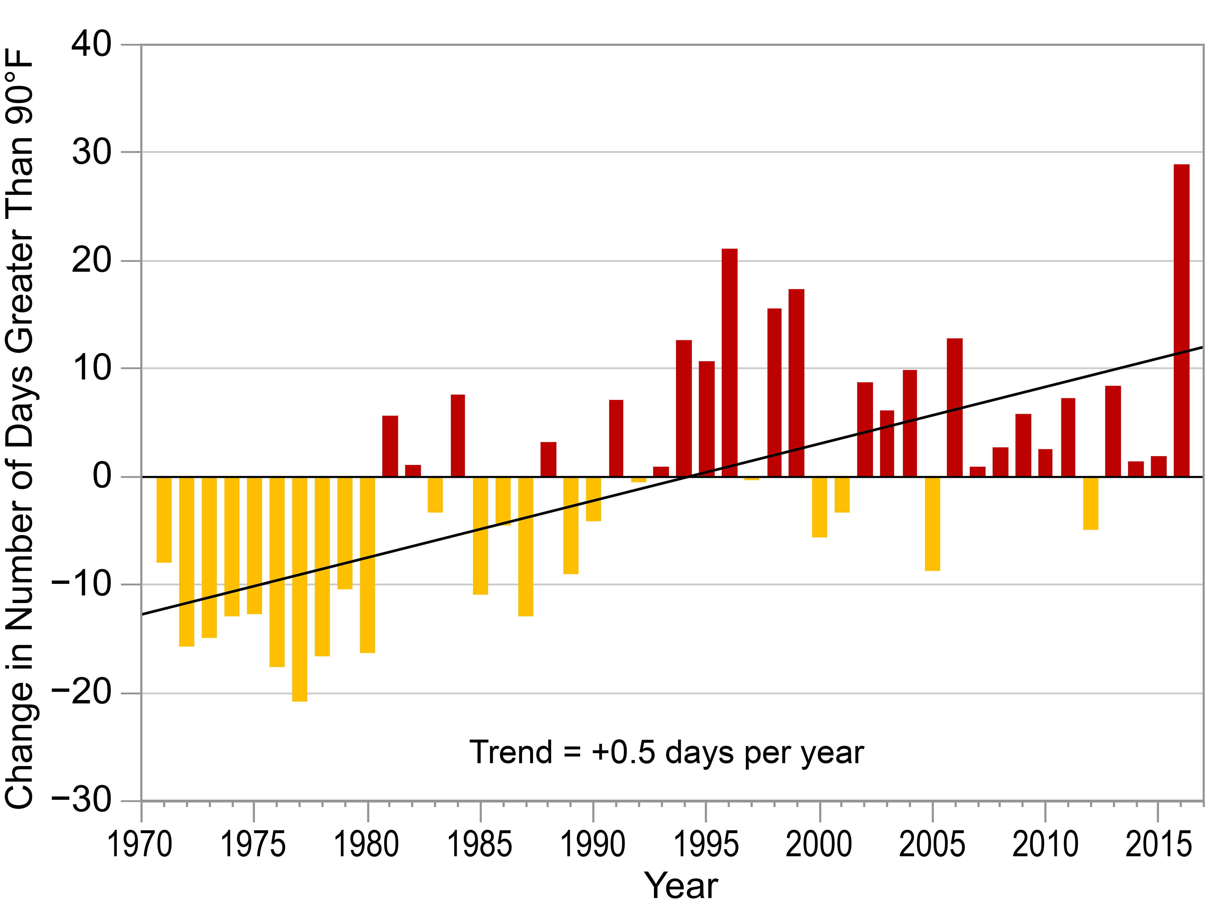
Key Message 4: Rising Temperatures
Natural and social systems adapt to the temperatures under which they evolve and operate. Changes to average and extreme temperatures have direct and indirect effects on organisms and strong interactions with hydrological cycles, resulting in a variety of impacts. Continued increases in average temperatures will likely lead to decreases in agricultural productivity, changes in habitats and wildlife distributions, and risks to human health, especially in vulnerable populations. As maximum and minimum temperatures increase, there are likely to be fewer cool nights and more frequent hot days, which will likely affect the quality of life in the U.S. Caribbean. (High Confidence)
Description of evidence base
In warm tropical areas like Puerto Rico and the USVI, higher summertime temperatures mean more energy is needed to cool buildings and homes, increasing the demand for energy. Heat episodes are becoming more common worldwide, including in tropical regions like the U.S. Caribbean. Higher frequency, duration, and intensity of heat episodes are triggering serious public health issues in San Juan. Heat poses a greater threat to health and well-being in high-density urban areas. Land use and land cover have affected local climate directly and indirectly, facilitating the urban heat island (UHI) effect, with potential effects on heat-related morbidity and mortality among urban populations.
Major uncertainties
Warming is evident. A remaining scientific question is how ecological and social systems that have established themselves in a particular location can adapt to higher average temperatures.170 Islands such as Puerto Rico are particularly vulnerable because of heat events associated with changes in both terrestrial and marine conditions. Although there is evidence suggesting that mortality relative to risk increases in San Juan due to extreme heat,12 this association is not completely understood on tropical islands like Puerto Rico and the USVI. Addressing such hazards can benefit from new strategies that seek to determine linkages between human health, rapid and synoptic environmental monitoring, and the research that helps improve the forecast of hazardous conditions for particular human population segments or for other organisms.
Description of confidence and likelihood
There is high confidence that increasing temperatures threaten the health and well-being of people living in the U.S. Caribbean, especially in high-density urban areas where the UHI effect places further stress on city populations.
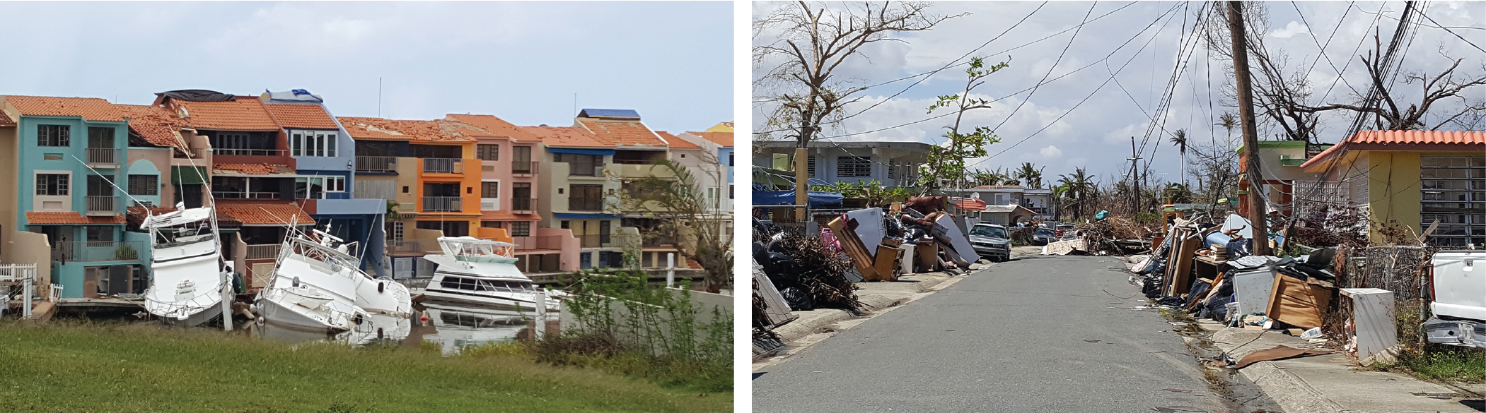
Key Message 5: Disaster Risk Response to Extreme Events
Extreme events pose significant risks to life, property, and economy in the Caribbean, and some extreme events, such as flooding and droughts, are projected to increase in frequency and intensity (flooding as likely as not, medium confidence; droughts very likely, medium confidence). Increasing hurricane intensity and associated rainfall rates (likely, medium confidence) will likely affect human health and well-being, economic development, conservation, and agricultural productivity. Increased resilience will depend on collaboration and integrated planning, preparation, and responses across the region (high confidence).
Description of evidence base
On both Puerto Rico and the USVI, disaster events have caused billions of dollars in property and crop damages.171 Over the years, disaster-induced casualties have declined in both territories. Tropical cyclones, particularly hurricanes, continue to generate the most severe economic damage across the U.S. Caribbean. Floods and droughts are challenging to manage for both territories, and these challenges may be exacerbated by climate change induced shifts in precipitation regimes.
Climate modeling for tropical cyclone activity in the Atlantic Basin, including the Caribbean region, points toward an increase in the frequency of more intense hurricanes.135 An increase in days with more than 3 inches of rain per 24-hour period is projected for Puerto Rico, based on statistically downscaled CMIP3 climate models.28 Changes in precipitation patterns are expected for Puerto Rico in the periods 2030–2050 and 2100, pointing toward an overall decrease in mean precipitation for different climate change scenarios.7,28,30,34
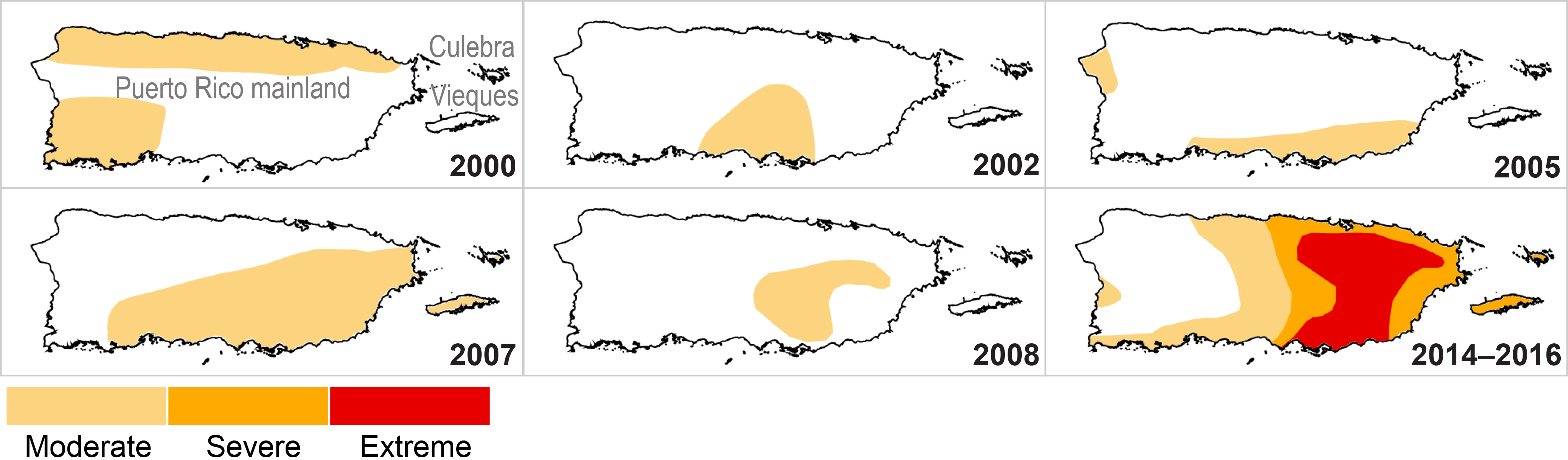
While continental droughts typically affect vast regions, droughts affecting Puerto Rico and the USVI tend to vary significantly in extent and severity over smaller distances.132 Statistically downscaled climate projections for Puerto Rico suggest an increase of drought intensity (measured as the total annual dry days) and extremes (measured as the annual maximum number of consecutive dry days) due to an increase in mean and extreme temperatures and a decrease in precipitation.7
An increase in mean atmospheric temperature has been observed across the U.S. Caribbean islands, particularly on Puerto Rico. An analysis of the observed temperatures across several NOAA weather stations in Puerto Rico showed rising temperature trends between 1970 and 2016.172 Following the principles established by the international Expert Team on Climate Change Detection and Indices,173 temperature extremes and trends were identified, indicating significant increases in rising annual temperatures and an increase in extreme heat episodes.
Major uncertainties
There are still uncertainties as to how these projected changes in tropical Atlantic cyclone activity will affect the frequency distribution of extreme precipitation events. While an increase in days with more than 3 inches of rain per 24-hour period has been projected based on statistically downscaled CMIP3 models,28 more recent generations of GCMs do not show this increase in extreme rainfall events, and this adds uncertainty. Results from two dynamically downscaled climate models using the most recent generation of GCMs for the region do not show increases in the frequency of extreme events.34
At present, data pertaining to the costs and effects that are associated with extreme events and disasters are very limited and not readily accessible for government officials, disaster risk managers, or the general public. In the future, more accessible data could facilitate opportunities for more thorough analyses on the economic costs of extreme events for the U.S. Caribbean.
Description of confidence and likelihood
There is high confidence that increasing frequency of extreme events threatens life, property, and economy in the region, given that the U.S. Caribbean’s vulnerable populations and fragile economies are continually exposed to climate extremes. There is medium confidence that the frequency and intensity of the most extreme hurricanes and droughts will likely increase. There is high confidence that extreme events will likely continue to affect human health and well-being, economic development and tourism, conservation, agriculture, and danger from flooding. There is high confidence that future recovery and cultural continuity will depend on significant and integrated resilience planning across the region, focusing on collaborative actions among stakeholders.
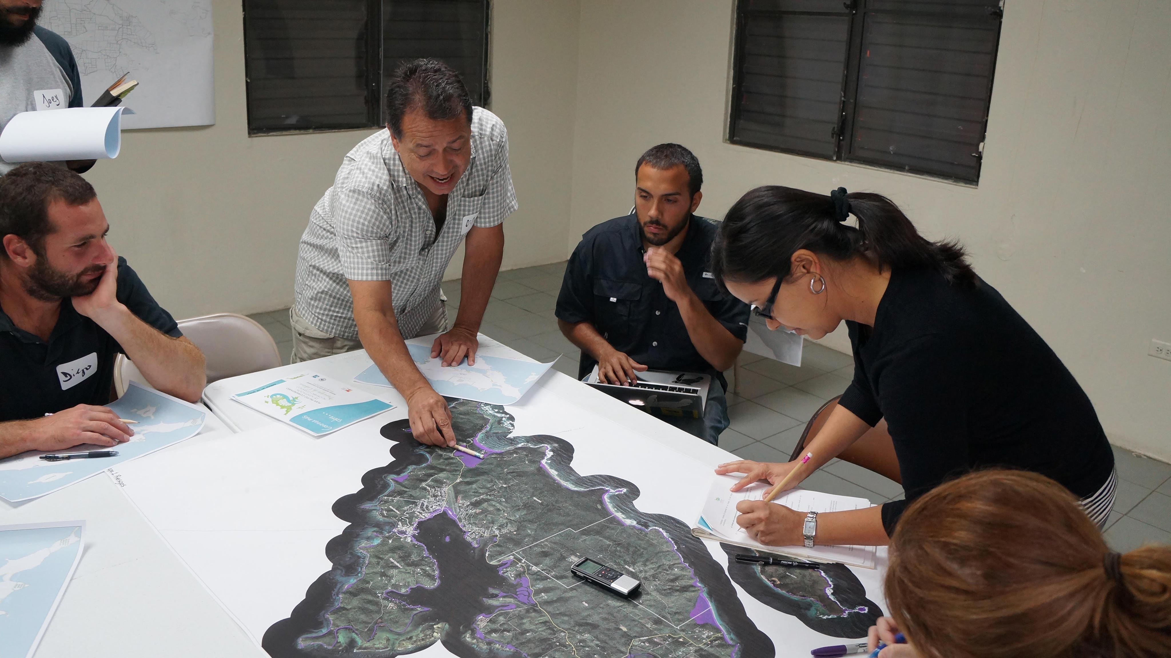
Key Message 6: Increasing Adaptive Capacity Through Regional Collaboration
Shared knowledge, collaborative research and monitoring, and sustainable institutional adaptive capacity can help support and speed up disaster recovery, reduce loss of life, enhance food security, and improve economic opportunity in the U.S. Caribbean. Increased regional cooperation and stronger partnerships in the Caribbean can expand the region’s collective ability to achieve effective actions that build climate change resilience, reduce vulnerability to extreme events, and assist in recovery efforts (very likely, high confidence)
Description of evidence base
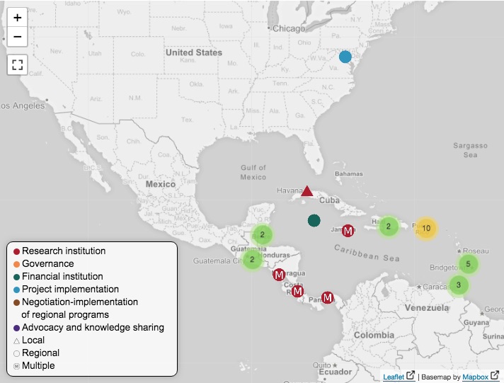
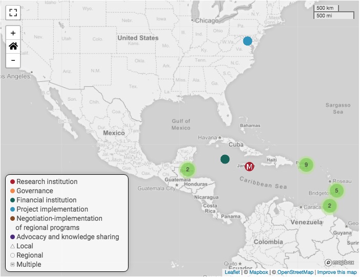
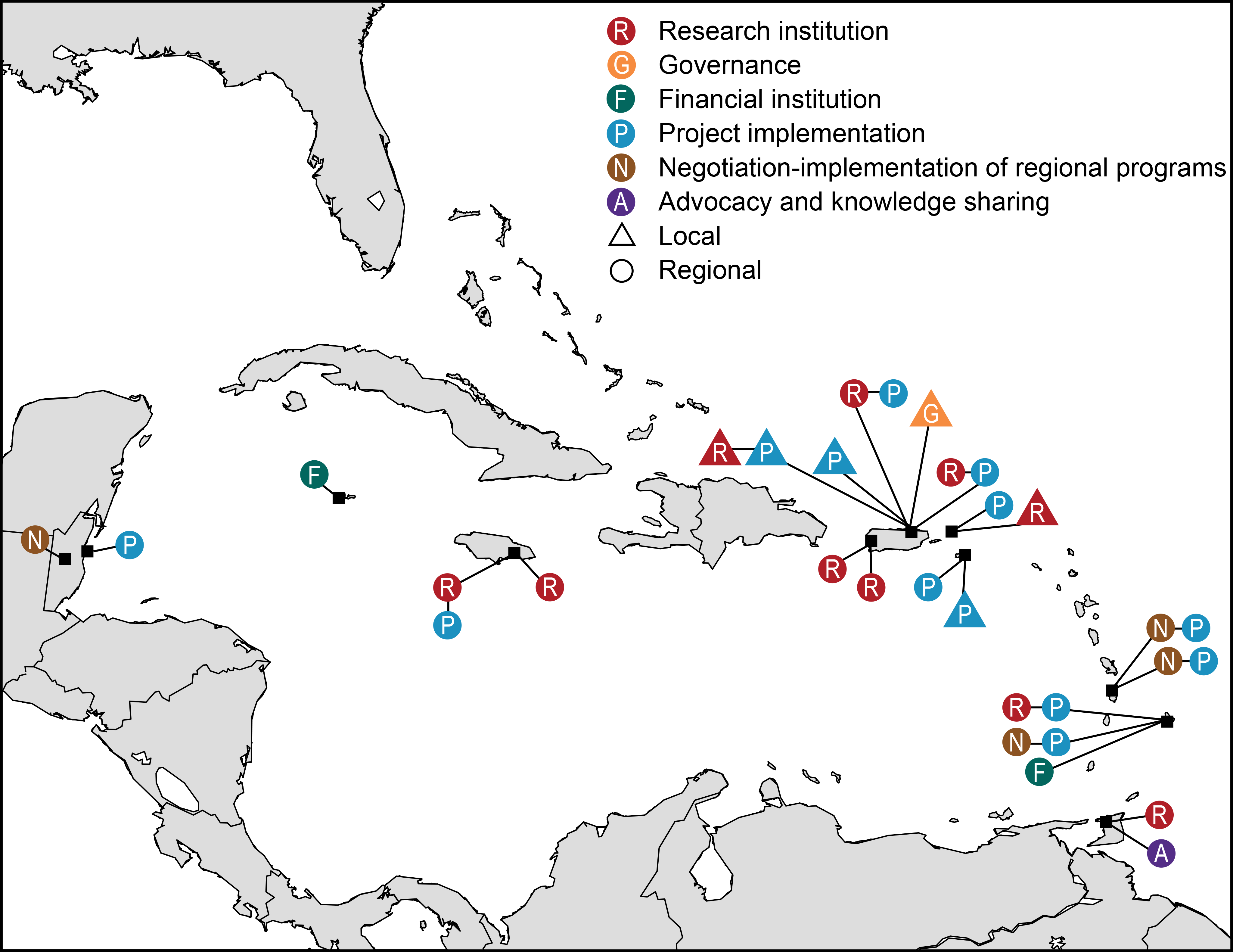
Cross-regional and international cooperation is a mechanism that will likely reduce climate vulnerability and risks in the U.S. Caribbean, because it builds capacity and leverages resources in a region that has low adaptive capacity, due in part to the high costs of mitigation and adaptation relative to gross domestic product.1,17,145 There are several efforts among the islands focused on coordination, information exchange, and approaches for risk assessment and management in the Caribbean region.142,143,144,145 There are emerging opportunities for improving these partnerships and capacity across the region.
Major uncertainties
There is high certainty that Caribbean island states are being affected by climate change, but the rate and degree of effects vary across countries due to the differences in environmental and socioeconomic conditions. Examples of regional cooperation efforts to share knowledge, conduct collaborative research, and develop joint projects have increased the adaptive capacity in the region; however, sustaining such efforts across the region remains a challenge. As efforts for regional coordination, cooperation, and information exchange evolve, evidence of the benefits of collaboration can be better assessed.
Description of confidence and likelihood
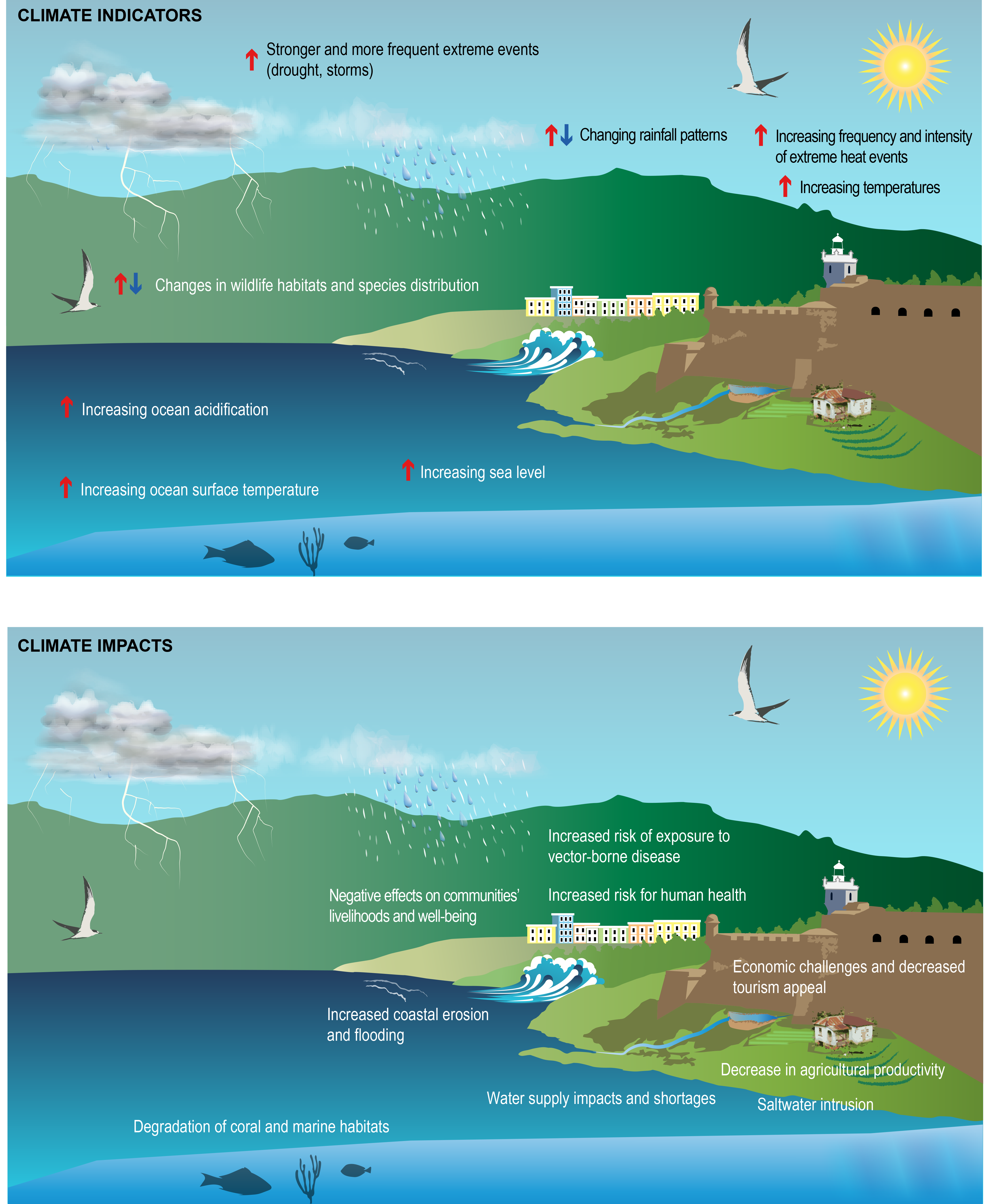
There is high confidence that climate change will likely result in serious water supply shortages and in increased risks for agriculture production, human health, wildlife, and the socioeconomic development of Puerto Rico, the USVI, and the wider Caribbean region. The effects of climate change in the Caribbean region are likely to increase threats to life and infrastructure from sea level rise and extreme events; reduce the availability of fresh water, particularly during the dry season; negatively affect coral reef ecosystems; and cause health problems due to high temperatures and an increase in diseases.


